

The Conduct Cadastral Survey course trains learners to determine, mark, and document land boundaries for legal land ownership and registration. It covers reconnaissance, establishment of control points, boundary surveying, beacon monumentation, data computation, and preparation of cadastral plans using CAD and GIS tools, while ensuring legal compliance and professional ethics.
- Teacher: Admin User
Cadastral Survey
Definition:
A cadastral survey is a survey conducted to define, establish, or re-establish the boundaries of parcels of land and to provide accurate records of land ownership.
It is primarily concerned with land ownership, boundaries, and land registration.
Objectives / Purpose:
-
To determine and demarcate legal land boundaries.
-
To support land registration and title issuance.
-
To provide legal certainty of land ownership.
-
To resolve boundary disputes between landowners.
-
To facilitate land taxation, transfer, and development.
Key Features of Cadastral Survey:
-
Focuses on property boundaries.
-
Produces survey plans that are admissible in court.
-
Often involves boundary pegging or marking.
-
Supports the land registry and cadastre system.
Instruments / Tools Used:
-
Total Station: Measures angles and distances accurately.
-
Theodolite: Measures horizontal and vertical angles.
-
GPS / GNSS Receivers: Provides precise coordinates.
-
Measuring Tape / Chain: For short distances or verification.
-
Plumb bob, ranging rods, and pegs: For physical demarcation.
Steps in Conducting a Cadastral Survey:
-
Preparation / Desk Study
-
Review previous survey records, maps, and land titles.
-
-
Reconnaissance
-
Visit the site to identify existing boundaries, landmarks, and encroachments.
-
-
Field Survey
-
Measure distances, angles, and positions of boundary markers.
-
-
Boundary Marking
-
Place physical markers (pegs, stones, or posts) along property boundaries.
-
-
Mapping / Drawing Plans
-
Prepare cadastral maps showing boundaries, dimensions, and neighboring parcels.
-
-
Submission / Registration
-
Submit survey plans to the land registry for official record.
-
Applications of Cadastral Survey:
-
Issuing or updating land titles and deeds.
-
Settling land disputes and encroachments.
-
Planning land subdivision and development.
-
Land taxation and valuation.
-
Supporting urban planning and land management.
- Teacher: Admin User
Principles of Land Law
Definition:
Land law is the branch of law that governs the ownership, use, and transfer of land. It establishes the rights and duties of landowners and users in accordance with legal frameworks.
Key Principles of Land Law:
-
Doctrine of Ownership
-
Land can be owned by individuals, communities, or the government.
-
Ownership rights may include possession, use, and transfer.
-
-
Principle of Security of Tenure
-
Protects individuals or groups from illegal eviction.
-
Ensures rights of lawful occupants are recognized and enforceable.
-
-
Principle of Registration
-
Land ownership and interests must be officially recorded in land registries.
-
Provides proof of ownership and facilitates transactions.
-
-
Doctrine of Public Trust / State Control
-
Certain land may be held by the state for public purposes like roads, parks, and infrastructure.
-
Land use is subject to regulations and planning laws.
-
-
Principle of Transferability
-
Land can be sold, leased, mortgaged, or inherited, subject to law.
-
Transfers must follow legal processes to be valid.
-
-
Principle of Limitation and Prescription
-
Land rights may expire or be acquired through long-term use (adverse possession).
-
Encourages regularization and certainty of ownership.
-
-
Doctrine of Encumbrances
-
Land may be subject to charges, leases, easements, or mortgages.
-
These affect ownership rights and use but do not transfer full ownership.
-
-
Principle of Land Use Planning and Zoning
-
Land must be used according to approved plans, zoning laws, and environmental regulations.
-
Ensures orderly development and sustainability.
-
-
Principle of Equitable Treatment
-
Land laws aim to ensure fairness and justice in access, ownership, and dispute resolution.
-
Applications:
-
Land registration and title management.
-
Dispute resolution in land ownership and boundaries.
-
Regulation of leases, mortgages, and easements.
-
Planning and development of urban and rural areas.
- Teacher: Admin User
Engineering Survey
Definition:
An engineering survey is a type of survey conducted to provide accurate measurements, positions, and elevations of land and features to aid in the planning, design, construction, and maintenance of engineering works such as roads, bridges, railways, dams, and buildings.
It focuses on practical application of measurements for construction and civil engineering projects.
Objectives / Purpose:
-
Provide horizontal and vertical control for construction projects.
-
Establish alignments for roads, railways, pipelines, and canals.
-
Determine cut and fill volumes for earthworks.
-
Support design and layout of structures with accurate data.
-
Monitor structures during and after construction for settlement, deformation, or movement.
Types of Engineering Surveys:
-
Preliminary / Reconnaissance Survey
-
Determines the feasibility of a project and general site conditions.
-
-
Location / Layout Survey
-
Fixes exact positions of proposed structures on the ground.
-
-
Construction / Setting-Out Survey
-
Marks foundation lines, road edges, and other structures before construction.
-
-
As-Built / Final Survey
-
Records the exact positions and dimensions of completed works.
-
-
Monitoring / Deformation Survey
-
Measures settlement, deflection, or displacement of structures over time.
-
Instruments Used in Engineering Survey:
-
Total Station: Measures angles and distances for layout and mapping.
-
Theodolite: Measures horizontal and vertical angles.
-
Auto Level / Dumpy Level: Measures elevations for leveling and grading.
-
GPS / GNSS: Determines precise positions of points.
-
Measuring tapes / Chains: For short distances or verification.
Applications:
-
Construction of roads, railways, bridges, dams, and buildings.
-
Design and implementation of drainage, sewerage, and irrigation systems.
-
Volume calculation for earthworks and cut-and-fill operations.
-
Layout and verification of engineering structures.
-
Monitoring structural stability and deformation after construction.
- Teacher: Admin User
Topographic Survey (Topo Survey)
Definition:
A topographic survey is a detailed survey of the natural and man-made features of the land, including elevations, contours, and positional data. It shows the shape and features of the terrain to help in planning, design, and construction.
Purpose / Objectives:
-
Determine ground elevations and contours.
-
Identify natural features: rivers, trees, hills, valleys, and slopes.
-
Locate man-made features: buildings, roads, fences, utilities.
-
Provide base maps for civil engineering, construction, or land development.
-
Aid in drainage, grading, and landscape planning.
Key Components Captured in Topo Survey:
-
Elevation points and contour lines.
-
Roads, paths, and fences.
-
Buildings, walls, and other structures.
-
Water bodies (streams, ponds) and vegetation.
-
Utilities (sewer lines, power lines, pipelines).
Equipment / Instruments Used:
-
Total Station: Measures angles and distances accurately.
-
GPS / GNSS Receiver: Determines precise positions.
-
Auto Level / Dumpy Level: Measures elevations.
-
Theodolite: Measures horizontal and vertical angles.
-
Measuring Tape / Chain: For short distances and verification.
Steps in Conducting a Topo Survey:
-
Planning: Identify survey area, instruments, and control points.
-
Reconnaissance: Inspect site for access, obstacles, and major features.
-
Establish Control Points: Fix benchmarks or reference points with known coordinates.
-
Data Collection: Measure angles, distances, and elevations of all features.
-
Plotting / Mapping: Draw a topographic map showing contours, features, and elevations.
-
Verification & Submission: Cross-check measurements and submit maps/drawings.
Applications of Topographic Surveys:
-
Civil engineering and construction projects.
-
Road, railway, and bridge design.
-
Land development and subdivision planning.
-
Flood risk assessment and drainage planning.
-
Environmental and forestry mapping.
- Teacher: Admin User

Definition:
A survey instrument is a device or tool used in surveying to determine the relative position, distance, direction, or elevation of points on the earth’s surface.
Types of Survey Instruments:
1. Angular Measurement Instruments
-
Theodolite: Measures horizontal and vertical angles.
-
Total Station: Combines electronic distance measurement and angle measurement.
2. Distance Measurement Instruments
-
Measuring Tape / Chain: Simple linear measurement.
-
EDM (Electronic Distance Meter): Uses electromagnetic waves to measure distances accurately.
3. Levelling Instruments
-
Dumpy Level / Auto Level: Measures vertical height differences.
-
Laser Level: Projects a laser to determine elevations over longer distances.
4. GPS and GNSS Instruments
-
GPS Receiver: Determines precise positions using satellites.
-
GNSS Receiver: Supports multiple satellite systems for higher accuracy.
5. Specialty Instruments
-
Compass / Prismatic Compass: Measures bearings for navigation or orientation.
-
Planimeter / GPS Total Station Accessories: For mapping and plotting areas.
Purpose / Uses:
-
Measure distances and angles accurately.
-
Determine elevations and contours.
-
Aid in mapping and land boundary determination.
-
Support construction, engineering, and environmental planning.
- Teacher: Admin User
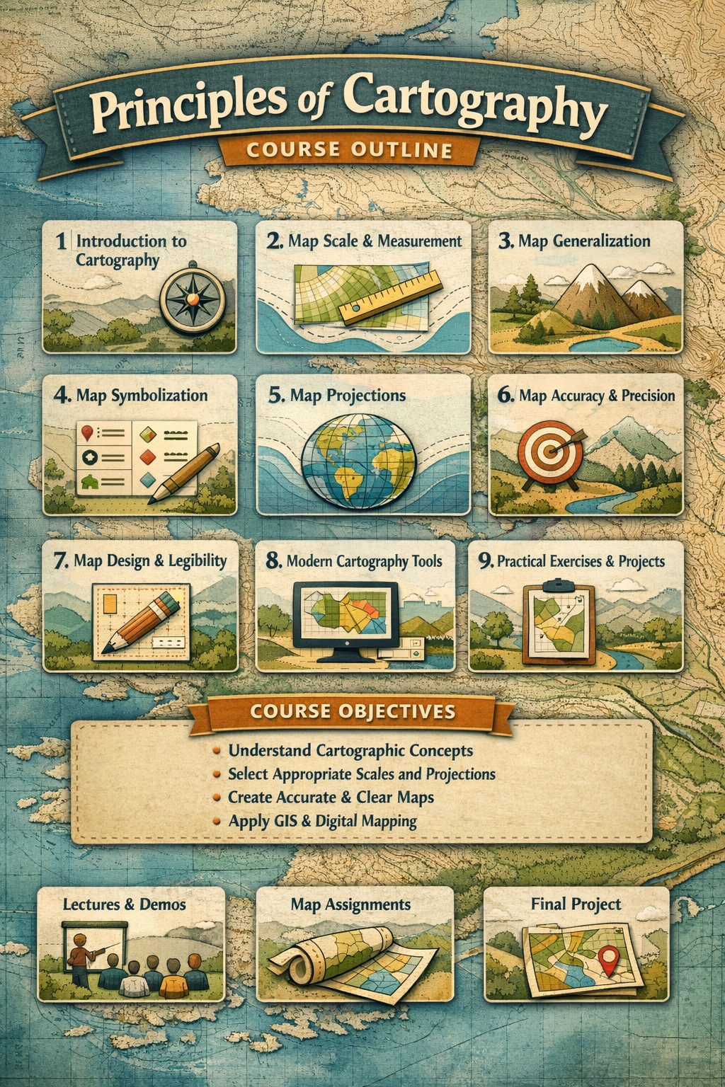
Course Title: Principles of Cartography
Course Description:
This course introduces students to the fundamental principles of cartography, including map design, representation, and interpretation. It equips learners with the skills to create accurate, legible, and meaningful maps for various applications, including surveying, GIS, and environmental studies.
Course Objectives:
By the end of the course, learners should be able to:
-
Understand the basic principles and concepts of cartography.
-
Select appropriate scales, symbols, and projections for different mapping tasks.
-
Apply generalization and symbolization techniques to enhance map clarity.
-
Produce accurate and legible maps for professional use.
Course Outline / Modules:
Module 1: Introduction to Cartography
-
Definition and scope of cartography
-
Importance of maps in surveying and spatial planning
Module 2: Map Scale and Measurement
-
Concept of scale (large-scale vs. small-scale maps)
-
Measuring distances and areas on maps
Module 3: Map Generalization
-
Selection of relevant features
-
Simplification, classification, and omission techniques
Module 4: Map Symbolization
-
Use of points, lines, and area symbols
-
Color schemes and patterns
-
Legends and labels
Module 5: Map Accuracy and Precision
-
Ensuring positional and thematic accuracy
-
Error sources and minimization
Module 6: Map Projections
-
Concept of projecting the 3D earth onto 2D surfaces
-
Types of map projections (cylindrical, conical, azimuthal)
-
Distortion in area, shape, distance, and direction
Module 7: Map Design and Legibility
-
Layout, balance, and visual hierarchy
-
Typography and symbol clarity
Module 8: Modern Cartography Tools
-
Introduction to GIS, CAD, and digital mapping
-
Integration of traditional and digital cartography
Module 9: Practical Exercises / Projects
-
Creating simple thematic maps
-
Applying scale, projection, and symbols
-
Map critique and improvement
Assessment Methods:
-
Quizzes and short tests
-
Practical map-making assignments
-
Final project: Design a map using course principles
- Teacher: Admin User

Introduction to Survey Theory
Survey Theory is the scientific study of the principles, methods, and tools used in surveying — the process of measuring and mapping the Earth’s surface.
It forms the foundation of all surveying work, providing the knowledge required to plan, collect, analyze, and interpret spatial data accurately. Survey Theory explains why we use certain instruments, how measurements are taken, and what mathematical or geometrical principles are applied to ensure accuracy and reliability.
- Teacher: Admin User